I was very unsatisfied with the results I got from the first round of trajectory simulation for the SSJ-100 crash in Jakarta a week ago (blog article here: SSJ 100 descent: Innocent but deadly - Part 1). It does not match the crash site. I tried to find the cockpit photos by my friend Andy D (@infohots) who went on the first flight, to no avail. I felt that extrapolating based on the First Officer's panel alone is really a waste of time. No matter how I try to find alternatives, I keep coming back to the same conclusion.
All that changed today when Andy turned up again on the net and posted at the SSJ-100 crash topic in Indoflyer, and that he contacted me as well. His photos in Photobucket ran out of bandwidth and he loaded it elsewhere. I asked him to send the originals to me, so he did, along with what he can remember from his flight. It changed everything!
 |
| Captain's Panel (photo by Andy D/ @infohots) |
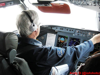
The Captain's Primary Flight Display showed basically the same thing as the first officer's, and the detail of the new photos corrects a few errors I made:
- Aircraft Indicated/Calibrated Airspeed: 238 knots
- Aircraft was passing 7300ft (the difference with the other photo is only a matter of timing)
- Autopilot was on, with Heading Select mode and Vertical Speed mode (029° and -1300 feet per minute), Altitude Select was 6000ft (not 2500).
The major difference in finding is on the Captain's Navigation Display:
- Aircraft's Flight Management Computer was programmed and at the the aircraft was tracking towards a pseudo-waypoint called AL01 (position is roughly 150° at 3 nautical miles from AL Non-Directional Beacon)
- The cyan coloured dashed-line, is actually a course-line from Halim VOR, with the selected course inbound of 241° which would put it very near the the Instrument Landing System localizer centerline for runway 24.
- The display range is set at 40 nautical miles, giving the dashed white arc a distance of 20 nautical miles from the aircraft. This differs from the First Officer Navigation Display, set to 20 nautical mile range.
- The green line showing the aircraft's planned track, forward of the aircraft is the same as the First Officer's, BUT, the difference (thanks to the larger selected display range), shows that the aircraft had only been going straight for 15 nautical miles or so. This contradicts the previous assumption of 25 nautical miles or so in the previous article.
 |
| First Officer's Panel (Photo by Andy D / @infohots) |
A closer look at the First Officer's Navigation display, also reveal some changes. The cyan coloured dotted line, does not represent the previous flight path (this was a VERY stupid mistake for me to make!), as mentioned above, it is a course-line from Halim VOR. The previous article assumes that the line was tracking a course of 195°. Closer inspection, and some revised analysis reveals that the course line was selected to 200°.
These findings, invalidates the planned flight path assumptions made in the previous article. The revised assumption of the flight path of the first demo flight is:
I have decided to not clutter the map with my writing, but marked key items in the map.
For the Cyan coloured items:
1 A line depicting a course of 200° outbound from Halim VOR.
2 A 20 nautical mile radius ring.
3 AL Non-Directional Beacon.
The Magenta coloured items:
1 Aircraft took off from runway 24, and made a left turn to the southwest towards Bogor Training Area while climbing to 10,000ft.
2 Entering Bogor Training Area, aircraft turned left to the east.
3 A right-hand orbit (360° turn) was made at position HLM200/20 (20 nautical miles from Halim VOR on radial 200°).
4 After completing the orbit, aircraft leaves Bogor Training Area towards AL01, and begins to descend to 6,000ft sometime after completing the turn.
5 Approximate position of aircraft when the flight deck photos were taken (Near radial 150° at 10 nautical miles from Halim VOR), as aircraft descended towards 6,000ft. Aircraft then descended further along the magenta line until on the ILS for runway 24, and landed.
Note: Bogor (Atang Sanjaya) Training Area (WIR4) coordinates for those interested, are: 06°31'00"S 106°30'00"E, 06°31'00"S 106°50'00"E, 06°38'00"S 106°50'00"E, 06°38'00"S 106°30'00"E, 06°31'00"S 106°30'00"E, and extends from the Ground to 6,000ft.
This is hugely different from what was written in my previous article, but this is based on Andy D's story, which I view as reasonably accurate. We also know that the second flight, took off from runway 06. Just like in the previous article, I am assuming that at least one waypoint remains the same: HLM200/20 (20 nautical miles from Halim VOR at radial 200°).
My assumption of the second flight:
For the Cyan coloured items:
1 A line depicting a course of 200° outbound from Halim VOR.
2 A 20 nautical mile radius ring.
The Magenta coloured items:
1 Aircraft took off from runway 06, and made a right turn to intercept the Halim VOR radial 200° whilst climbing to 10,000ft.
2 Aircraft continued on a course of 200° and reached 10,000ft, to enter the Bogor Training Area. The request to descend to 6,000ft and the right hand orbit would be made shortly after this.
3 After entering the training area, a right-hand orbit (360° turn) was made at position HLM200/20 (20 nautical miles from Halim VOR on radial 200°), and the aircraft also descended to 6,000ft. Note: This should keep the aircraft within the training area throughout the orbit turn.
What should have happened then:
4 After completing the orbit, aircraft leaves Bogor Training Area on the same heading before performing the orbit, and it is to obtain Air Traffic Control (ATC) Clearance to head back to Halim for the approach to runway 06.
5 Aircraft would continue to descend to 1600 until performing a visual approach to runway 06, or reach the position of HLM250/5 (5 nautical miles from Halim at radial 250°), and land.
We know points 4 & 5 never happened because the aircraft never made it back to the airport. But why?
What may have happened:
After completing the orbit, to go back to Halim Airport, the crew would have had to notify ATC of their intention and obtain clearance for it. However, we know that the ATC handling that area is at Soekarno-Hatta Airport (CGK), handling approach and departures through the area to/from that airport, and also covering aircraft going in and out of Halim Airport that is not at the Tower Frequency. At that time of day, it is the beginning of the afternoon rush hour at CGK, and the ATC handling the Sukhoi Superjet could also be handling about another 15 aircraft, in an area from Halim to the north.
The ATC frequencies can be quite busy during the rush hour period, and there is a possibility that the Sukhoi could not talk to the ATC (the radios only permit one station to talk at any one time). If they could not get to talk to the ATC due to the amount of other traffic, the crew would do what others are trained to do, maintain the last heading after completing the orbit. Unfortunately, this headed straight to Mount Salak. The Yellow Triangle with the Red Outline shows the possible path of the aircraft doing that, and we can see that if they didn't hit the peak, they would be very close to it.
I'm sure this would raise some questions:
1. Why didn't they just continue as planned by turning back towards Halim or remain in the Training Area?
Well, they asked for clearance to orbit, this is because they filed for a flight with a set of waypoints. However, doing an orbit isn't normal for "flying from A to B", so unless ATC asks them to do something else, they had to ask the ATC. They could have asked the ATC to make a right orbit and then proceed as filed back to Halim, but that would be our 20/20 hindsight asking. Yes, it would be better if they did, but it is perfectly acceptable not to.
2. Perfectly acceptable not to? But surely they must have known they were heading towards a mountain?
Again, that is our 20/20 hindsight talking. If they knew they were going to hit a mountain, they would have avoided it. You do not need to ask permission from the ATC to avoid Cumulus Granitus (aka: MOUNTAIN)... you avoid it first, then tell the ATC later.
Again, there are indications that the mountain was obscured by cloud, so they wouldn't see it while they were in transit towards the training area.
 |
The weather imagery by LAPAN showing weather conditions
near Mt. Salak at the time of the accident. |
3. If the mountain wasn't covered by cloud in the previous flight, surely they would have remembered?
Not quite. Remember what I wrote in part 1:
We have the luxury in this article with the chart that has terrain information. It is reported that the crew did receive a local area briefing for Bogor Training Area, which describes the area, including the surrounding terrain, and should have included information on Mt. Salak. The charts showing the terrain would likely be VFR (Visual Flight Rules) charts, which does not include airway information, but a lot of other information for VFR flying. Yes, the pilot had to sign off that he received the briefing. However, he planned to fly at 10,000ft. Mt. Salak is only 7200ft. Attention would probably be given to the nearby and much bigger Mt. Pangrango.
If we look at the Lido chart above, we can see the MORA (Minimum Off Route Altitude) is 11,900ft. This is to give adequate clearance from Mt. Pangrango at 9,900ft, not Mt. Salak.
Furthermore, the charts the crew used, are Jepessen charts. They would not be using any Standard Instrument Departures (SIDs) or Standard Arrivals (STARs), since they're not going to another city, they would not be looking at the en-route chart except maybe for checking the MORA. The approach chart for Halim, has terrain information MSA of 6,900ft south of HLM VOR, but nothing else, and the mountains are outside the MSA circle and not covered by the approach charts.
4. So why did they descend during the orbit on the second flight but not at the first flight?
The simple explanation would be, the runway change. As I said before in the previous article, it is a general rule of thumb for jet aircraft to need 3 nautical miles to lose 1000ft of altitude. To descend 10,000 feet they would need a distance of 30 nautical miles. Even with this revised speculation, if they would be too high for the approach if they didn't descend from 10,000ft by the time they completed the orbit. Again, mental calculations would be going on in the pilot's head as they plan for the descent. If they would make the orbit at 20 nautical miles from the airport, they can make a 180 turn after the orbit, after complete that turn they would also be at 20 nautical miles from the airport. 6,000ft needs 18 nautical miles, and they still got that final approach segment of 5 nautical miles. So, descending to 6,000ft so you can be at that altitude at 20 nautical miles, is perfectly normal. The runway change from runway 24 to runway 06, had shortened the flight by a significant amount, hence the major difference in top-of-descent points between the two fligths.
5. Surely they would have the right charts to keep them away from terrain?
This was an IFR (instrument flight rules) flight and not a VFR (visual flight rules) flight. I am not going to discuss this much on this article, I had covered it enough in the previous article about what charts they used (Jeppesen charts, the ones used in my articles are Lido charts). However, just to show what charts they had in front of them, these photos shows it all:
 |
| Chart on left is an approach chart, chart on right is an airport ground chart |
 |
Approach chart shown for the first flight, the second flight would
have that chart replaced with the one for runway 06. |
Note that no other charts are visible, no enroute charts, no VFR charts, and yes, this is perfectly acceptable for short IFR flying to and from the same airport.
Changes from Part 1?
The Bogor Training Area argument made by the ATC, is logical, and relatively innocent (I'm not into the blaming game... that's for criminal investigators and lawyers... I'm here for safety, which needs a "blameless" investigation, or in my case, objective speculation.
The other change is that this can now explain the orbits. These are made when you need to extend the flight time, such as for sales demonstration flight like this. It also means that the crew were aware of the general local environment, and in a reasonable and foreseeable attempt to mitigate risk, they chose to use the Bogor Training Area, and make the orbits to extend the flying time by an acceptable amount. However, neither the crew nor the ATC, could have reasonably foreseen (without hindsight) the significant increase in risk posed by the runway change, as the planned use of the Training Area was perfectly safe for operations with runway 24 at Halim. Well, they didn't use the Training Area, they used the area above the training area, this provided additional safety margin from the surrounding terrain... as long as you fly to/from runway 24. Unfortunately, the second flight used runway 06.
Conclusion:
Runway changes screws up pilots' descent planning on a daily basis. These guys on the Sukhoi were good, very good! Top notch test pilots, they stayed ahead of their game in the descent planning in an unfamiliar situation, but at the cost of additional risks they did not foresee (and not out of carelessness), to which blame-pointers will feast on the dead. In my opinion, it remains that lack of familiarity with local operating conditions, resulted the tragedy. Possible busy ATC and its radio frequency, and its effects in conjunction with the surrounding terrain, was likely not foreseen by anyone involved in the planning.
Again, I will say that unless the investigators find something else, the information currently available to the public, does not indicate any "pilot bravado" or "ATC cover-ups" (in fact, they're quite open about it but will not disclose anything more than what they need to disclose at this point in time).
This article, is just an objective speculation aimed at answering some of the questions running around everyone. The truth at the end of the day can be close to this, or very far from this. However, it is my hope that this article can provide answers against reckless speculators, and the blame-pointers.
I end this article by saying that the simple question on why they descended and why ATC gave them permission to do so, in my books, is answered; and that one of my flight simulator guinea pigs, tested the above theory. His aircraft didn't end up in the mountain, but it very nearly did, and at 6000ft he missed the crash site by a mere 500 meters...